|
|
|
|
Location: Manning Valley
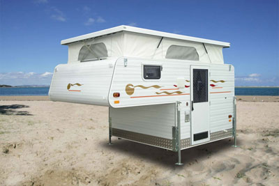
November 25, 2007. My experience thus far with the mini Odysseys has taught me a few things, such as the kind of rig I'll need for the 'big one'. I rather enjoy the back roads, rough as they may be, in order to see the things most people don't. I'm a nooks and crannies person. So, I have serious doubts about TT's ability to do the job adequately. I've also changed my mind about towing a caravan. It's too cumbersome. Now, I'm thinking a 4WD ute (pickup) fitted with a slide-on camper. Admittedly, a slide-on has less interior space than a regular caravan, but it's also more practical - able to negotiate secondary roads and situations where caravans are disallowed. In any case, it's the exterior space I'm more concerned about... the great outdoors! A vehicle fitted with 4WD will also allow access to places where a 2WD would be in all kinds of bother. See you on the next adventure. November 18, 2007. Yes, back in the Manning Valley this week, at a place called Coorabakh National Park (1827 hectares), best known for its impressive rock outcrops, Big Nellie 560m, Little Nellie 555m and Flat Nellie 485m. My mother was nicknamed Nellie and hated it because it rhymed with Kelly. Her name was Ellen. Coorabakh also features spectacular sandstone cliffs with stunning views across the valley. The cliff line is known as the Landsdowne Escarpment and rings the Manning Valley to the north. Click here for the photo album or read on and click the link at the end of this article.
AND THEN, I got stuck behind about 30 cyclists, all wearing ultra-tight lycra shorts and the rest of the obligatory professional cycling gear... on a windy road (as opposed to breezy) that didn't allow overtaking for a couple of miles. Grrrr. But I wasn't gonna argue with 30 fit pedalers. One amazing visual was when we all approached a tight bend. As the group turned to the right in front of me, to cross a railway track, I suddenly realized how many they were. Prior to that, they looked like a tightly packed bunch of bums, saddles and piston calves. So I drove further up the highway to Moorland where I found Forest Drive, which runs in a loop through Coopernook State Forest. I imagine a Sherman tank could negotiate some of the rough roads pretty well, but Tough Titties copped a hammering. Some of the surfaces weren't too bad, and she did survive the ordeal despite the hippy hippy shakes. I had a bit of trouble with my HP camera when I photographed panoramas from lookouts. It didn't know what to focus on. "Focus on EVERYTHING you dumb thing!" But it wouldn't listen, and kept giving me the red 'don't shoot' signal in the viewfinder. Even some of the shots that did turn out were a bit of a disappointment. Never mind, I'll keep practicing and I'll get better. Other shots that are less than satisfactory presented the camera with too wide a range of lighting, especially in areas where there was marked contrast between shade from heavy undergrowth and patches of bright sunlight. Newbys Cave is a case in point... only one pic turned out. Early morning and late afternoon, when the intensity of reflected light is not so harsh, are far more preferable times for that kinda photography. Big Nellie was also a bit of a letdown. There's a viewing platform there... if you like trees. I wondered where the bloody thing was before I realized it was above the tree tops. It's a huge volcanic plug. I spotted a walking track and began the trek (with some trepidation) to get a better view of Big Nellie. But some way up the climb, with no idea of how long or steep the rest of the climb was, I turned back. When I returned to the car, two carloads of family-type picnickers had arrived. I heard a bloke in his early 20s complain about the view: "Typical of State Forests," he said with a laugh," a viewing platform that you can't see anything from!" "It's up there," I said, pointing skyward. "Yeah, I know... I'm gonna climb it later on." "You're joking!" "Nope, I've climbed it three times already." "I got less than half way up the walking track and turned back." "What?" "I'm a wuss." "It's pretty easy... the sign says experienced climbers only but that's crap. It's not that hard." "You're insane." "Hahaha, nah... I'll be right, mate." So I had a cuppa and left them to it. If I'd had the time I would have hung around for the show. Flat Rock Lookout was another place where I had focus probs, but the view is nonetheless spectacular. Waitui Falls was cute... and pretty... and I managed my little Rudoph Nureyev hop across the rocks without taking an unscheduled dive over the edge. I stopped there and downed a nice cold beer, and contemplated the serenity of Nature for about 15 minutes, which was most pleasant. A bloke in a little Suzuki 4WD turned up and took a swim in the pool, which would have been a tad chilly... but it was a HOT day. Earlier in the day, I saw practically nobody else (which provided an ideal opportunity to take an outdoors leak on a few occasions). Even later, getting toward late morning and midday, I saw maybe a dozen people max. I left Waitui a few minutes before the swimmer, and moved over when he caught me on the dirt road. He was flying compared to me. I'm now wondering if the Odyssey is a practical proposition without a 4WD. On some of the rougher parts of the dirt/gravel roads, I had to negotiate fallen trees which, fortunately, were not in the process thereof. Occasionally, I'd meet another vehicle approaching from the opposite direction and it was a pretty tight squeeze at very low speed to get past. One thing that is peculiar to meeting just one or two people out in the wilderness is that you say g'day without hesitation. But if there's a dozen or more, you tend not to say anything. If Dr. Livingstone had been with a party of several people, Stanley may not have uttered a word. After Waitui, I headed along the final stretch of the loop to Hannam Vale, then to the Pacific Highway, and back to Taree. God bless sealed roads! Now that I've done a few mini-Odysseys, TT is getting longer legs... she's more willing to whiz along at 100kph than she was to start with. Yes, it was a worthwhile trip, and I got to see the three Nellies. My mom would have been pleased. I do suffer from vertigo, though. Before I took those pics of the telecommunications tower atop Vincents Lookout, I had to sit down... else I would have fallen down. That last climb frightened the hell outta me. As I approached the crest of the hill I half expected the road to suddenly end and present me with a sheer unfenced precipice. Oh! And I remembered to take a pic of the Taree Big Oyster for June in Ohio! Click here for the photo album PS: I hadn't realized it at the time but when I took the first of the pics, which features a sign post, I was already going the wrong way! Forest Drive was to the left! On the poz side, if I hadn't, I wouldn't have happened across Vincents Lookout. :o) Oh, and the swastika? I found it to be a curiosity way out there in the sticks. Vincents Lookout is rarely visited by the public, and the Telstra people who check the communications facility from time to time either haven't noticed it or can't be bothered erasing it. Come to think of it, the sign still says Telecom, and that name was changed to Telstra ages ago! Location: Great Lakes
We've had rain, rain and more rain the past two weeks so I didn't travel anywhere. Today was cloudy but mostly sunny... time to take a sticky beak. Tuncurry and Forster are two Mid North Coast towns separated by a large lake, but also connected by a modern bridge. It's about a half hour drive south of Taree along the Pacific Hwy, then along Tourist Drive 6 back to the coast. Fishing and tourism are the main activities, and both centers are bustling, modern examples of 21st century life. Multi-storey apartment buildings have replaced the fibro weekenders of the 50s and 60s, when mum and dad and the kids from Sydney spent a week or two camped in a tent for about ten bob. The area these days is a mini Gold Coast... a tad glitzy for my taste but nonetheless attractive. Over the bridge in Forster I was treated to the sight of an early-morning fisherman cleaning fish, which attracted quite a number of hungry mouths... sorry, beaks. When he finished cleaning the fish, he hosed off the metal table. All the pelicans gathered at one end and gulped the 'soup'. "They'll eat anything," I said. "Too bloody right, mate," he replied. Further down The Lakes Way, I turned left along a road that led to Cape Hawke, a place with which I was unfamiliar. Silly me! It was named by Captain James Cook way back in 1770 on his maiden voyage in The Endeavor up the Aussie coast. Cape Hawke lookout (420 meters at the summit) provides a spectacular 360 degree view of the surrounding ocean, lakes and towns. But it's a bit of a climb, mate, especially for this old dog. Too easy on the way down, though. Wheeeeeeee! Before the climb, while I poured a cuppa from the vacuum flask, and pigged out on a rissole sandwich with tomato and cheese, I met a couple from Brisbane. They noticed my T-shirt... bright red and emblazoned with the Buckeyes logo. Buckeyes? I have a friend in Ohio who has sent me more T-shirts over the years than I can fit in my closet. The Brisbane couple were expecting me to launch into an American accent, but no... 'g'day, mate'. The young bloke had been in Ohio the previous year and actually attended the National Championships game. He and his girlfriend were totally chuffed to see the shirt.... way out in the middle of nowhere on an Aussie mountain. That's the last thing they expected. After the climb (puff, puff), and subsequent descent, I was hanging out big time for a cold beer. Oh, wow, old TT was a welcome sight! The beer was waiting for me in the cooler. Then a 4WD pulled up. "I hope you're fit," I said to the bloke. His 'spare tire' was enormous, and I figured he probably won some sort of major prize in a nasal hair competition. He spoke with an accent, which I assumed was American. "Nope, I'm from Canada... we're civilized people." Hehe. Yeah, that tickled me. Then I got the diatribe about the "madman from over the border"... namely, GWB. "He's wrecked the country; the dollar's down, the economy is stuffed and he's spending trillions of dollars on wars! That's it, buddy, China's gonna be the new superpower." "I'll quote you on that." "Please do." BTW, the lookout tower on top of the mountain has a sign: "Climbing this tower is prohibited during electrical storms". Well, there ya go... one for the dummies. Like, who the hell's gonna climb the bloody mountain, let alone the tower, during a thunderstorm? Duh. Road signs? I'm glad you mentioned that. Ya know, when you're a first-timer somewhere and you DARE slow down to read a damn sign, you get the bloke behind you tooting his horn. Sheesh, that really boils my billy. I should've walked back to the driver behind me and asked him to go read the sign while I blew his horn. I have to thank my next door neighbor, Averelle (she gives me a hard time if I misspell it) for suggesting I check out The Green Cathedral, otherwise I would not have looked for it. Yes, it's delightful... definitely my idea of a place of worship. You can keep your Canterburys and Notre Dames (unless it's raining). Oh, and a goanna scurried past as I walked around, but he was only a little guy - about 2-3 feet or so. To read the transcript of The Green Cathedral "Dedication" click on this link. Yes, all in all, a most pleasant excursion with a bit of this and a bit of that, plus a couple of characters to natter with as a bonus. Oh, and the sailing club... yes, well, they sail on Sundays don't they, and this is a Monday. Next time. My rating? The beer and sandwich get a 10... the rest gets a 9. Surfers? Honest, I looked for signs saying "tanned people with surfboards" EVERYWHERE and didn't see a damn one. Nonetheless, I think the pics I took scrub up pretty well. Click here for the photo album
← Older posts
Journal Index
Newer posts →
|
 Rain,
rain and more rain, so I haven't been on a mini Odyssey this weekend. Today
is reasonably fine so far, but the back roads will remain muddy for a while.
In any event, more rain is forecast over the next week or so. On the real
Odyssey, of course, I'll be at the mercy of the elements... I'll be out
there in the thick of it 24/365. BUT, with a house on wheels, I'll be able
to check the forecasts and move to drier climes if need be.
Rain,
rain and more rain, so I haven't been on a mini Odyssey this weekend. Today
is reasonably fine so far, but the back roads will remain muddy for a while.
In any event, more rain is forecast over the next week or so. On the real
Odyssey, of course, I'll be at the mercy of the elements... I'll be out
there in the thick of it 24/365. BUT, with a house on wheels, I'll be able
to check the forecasts and move to drier climes if need be.
 I turned
left off the Pacific Highway at Coopernook and ran around in circles for
an hour. Do you think I could find Forest Drive? No way... signage is hopeless.
"Whaddaya talkin' about? I'm a local and I have no problem!" Yeah, right.
Locals must be in charge of road signage.
I turned
left off the Pacific Highway at Coopernook and ran around in circles for
an hour. Do you think I could find Forest Drive? No way... signage is hopeless.
"Whaddaya talkin' about? I'm a local and I have no problem!" Yeah, right.
Locals must be in charge of road signage.
 November
12, 2007. No, the pic of my neighbor Beau has nothing to do with today's
Odyssey. It's just that the other day I noticed an old dunny (loo) next
door and just HAD to take a pic... those things are a disappearing Aussie
icon. Beau volunteered to be the model. Meanwhile, today's jaunt covered
an area south of Taree, the Great Lakes: Tuncurry => Forster => Cape Hawke
(named by Captain Cook in 1770) => Pacific Palms.
November
12, 2007. No, the pic of my neighbor Beau has nothing to do with today's
Odyssey. It's just that the other day I noticed an old dunny (loo) next
door and just HAD to take a pic... those things are a disappearing Aussie
icon. Beau volunteered to be the model. Meanwhile, today's jaunt covered
an area south of Taree, the Great Lakes: Tuncurry => Forster => Cape Hawke
(named by Captain Cook in 1770) => Pacific Palms.